Skip to content
OnTrace

Every water point on your track, before you set off.

Import a GPX file: OnTrace places water, huts and supplies along your route, each with its kilometer. Then share the trace to prepare it as a team.

For now, OnTrace only works in mainland France and Corsica.

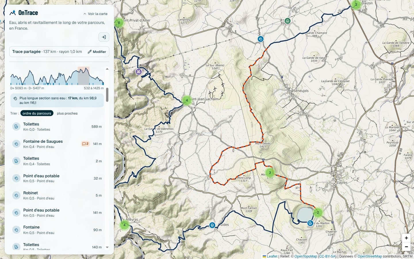
Hover or tap the profile to read the altitude and the distance to the next water. Tick the places to show: as in the app, the longest stretch without water is computed from the water points shown.

Longest stretch without water: 26 kilometers, from kilometer 97 to kilometer 123.

Track profileWater pointStretch without waterExample: a 137 km track in the Massif Central.

What you find along the trace

24 types of places, grouped as in the app, and camping zones. Tick what matters before you search: the rest stays one click away once the results are shown.

Water and hygiene

  • Water point
  • Cemetery (likely water)
  • Toilets

Shelter and lodging

  • Staffed hut
  • Unstaffed cabin
  • Hikers’ lodge
  • Shelter
  • Campsite
  • Accommodation

Food and drink

  • Café / bar
  • Restaurant
  • Food shop

Services and safety

  • Pharmacy
  • Cash machine
  • Defibrillator
  • Tricky passage

Transport

  • Train station
  • Bus station
  • Metro
  • Tram stop
  • Bus stop

Sightseeing

  • Viewpoint
  • Picnic area
  • Cave

Zones: wild camping

  • Camping allowed
  • Camping tolerated
  • Camping restricted
  • Camping forbidden

Zones drawn on the map, with their calendar. Where nothing is drawn, nobody knows.

Zones: protected area

  • Strict protection
  • Regulated area
  • Park territory

Parks and nature reserves, and what the rules forbid there. Without a zone, nobody knows either.

What changes out on the trail

Each feature answers a question you ask yourself when preparing a race or a trek.

  • The kilometer of each place

    Each place shows its exact kilometer along the route. Sort the list in race order, or by distance from the trace.

  • The longest stretch without water

    Spotted at a glance, dashed orange on the map and on the profile. You know where to refill before you leave.

  • The elevation profile

    Elevation gain and loss, lowest and highest altitude, with the water points marked all along the route.

  • A map that stays readable

    The essentials are preselected, and remembered from one visit to the next. Hide the surroundings of the start and finish, where towns crowd the map. Nearby markers group themselves.

  • Camping and protected areas, zone by zone

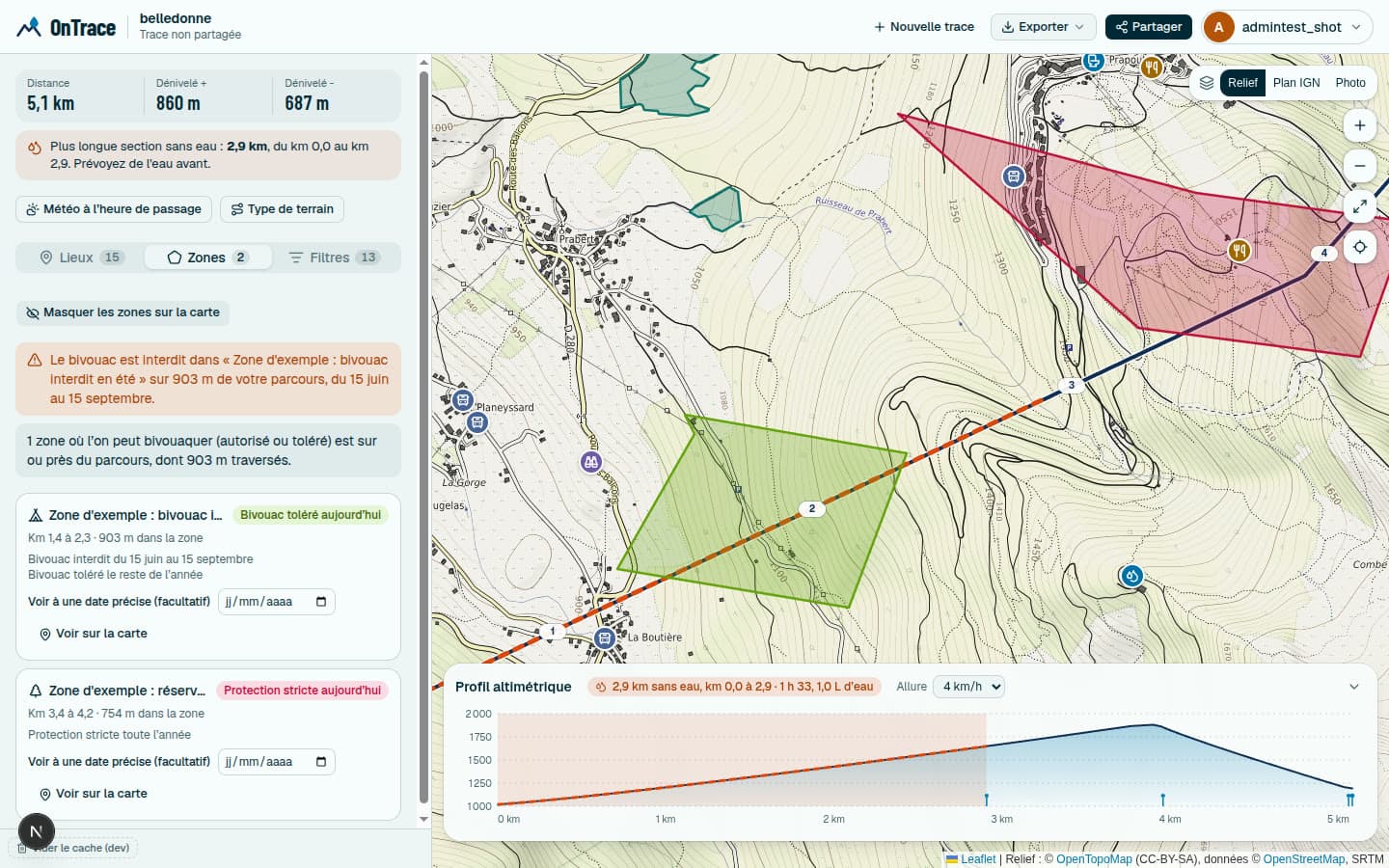
    Zones drawn on the map show where camping is allowed, tolerated, restricted or forbidden, and where parks and nature reserves begin. Each has its calendar: hover to read it, open it to pick a date. On your trace, a tab lists the ones you cross, with the kilometer and the period, and warns you of any ban. You can also draw your own freehand, for everyone or just for you.

  • Buses, trams, metros and stations

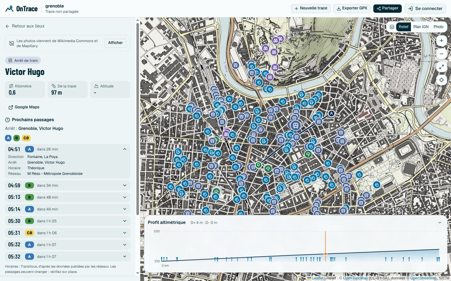
    Stops and stations along the route are places like any other. Open one: its lines show in color, with the next departures and real time when the network provides it. Timetables, regional coaches included, are only fetched at that moment.

  • How reliable each place is

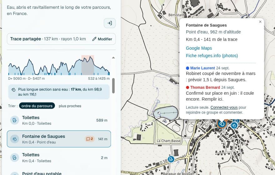
    Anyone can report the state of a place: flowing or dry, open, closed or temporarily closed, passable or not, with the date seen and a public note. The confidence level takes it into account, and a water point reported dry leaves the dry stretch calculation at once.

  • Recognize a place on the ground

    The photo of the place if OpenStreetMap has one, otherwise the nearest one on Wikimedia Commons. Its GPS coordinates to copy, and a direct link to Google Maps.

  • Prepare as a team

    Save the trace, send the link: everyone comments on places under their own name and color. The link alone gives read access, you decide who comments and who manages. Find all your traces, created or joined, in “My traces”.

  • An export for your watch

    Export the places shown as GPX waypoints, sorted in route order, with a Garmin icon, category and kilometer.

Inside the app

A real search on a 137 km track: the map, the elevation profile and the list of places follow one another in race order. Hover over the profile to find the spot on the map.

Screenshot of the app: the 137 kilometer track on the map, with its longest stretch without water dashed in orange. On the left, the distance, the elevation and the list of places in route order. Below the map, the elevation profile with the water points.
Screenshot of the app: a 5.1 kilometer track with two zones drawn on the map, in green and red. On the left, the Zones tab warns that camping is forbidden over 903 m from 15 June to 15 September, then lists each zone with its status for the day.
The zones on your trace. What the trace crosses, where and during which period, bans first. Hover over a zone on the map to read its calendar.
Screenshot of the app: the card of a city center tram stop with its lines A, B and C8 in color, the list of next departures and the details of one: direction, stop, scheduled time and network. Stops and stations appear on the map like other places.
Public transport. The lines in color and the next departures, fetched when you open the stop and not before.

Prepare the trace as a team.

The tap turned off in winter, the spring to check, the hut where the support crew waits: everyone notes it on the place, under their name and color. Everyone prepares the same trace, in the same place, before the start.

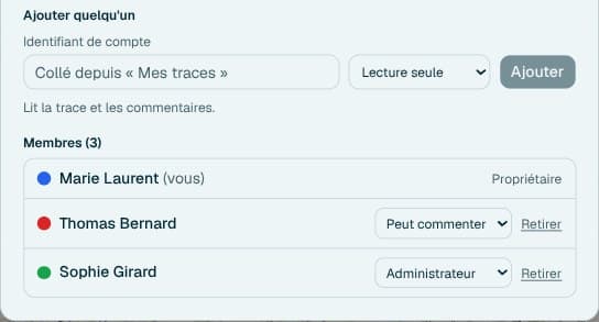
Screenshot of the app: the card of a fountain with its kilometer, its altitude and three dated comments from Nina_Trail, Marie_L and Thomas_B, each with an avatar in their color, and a field to add your own. The commented place has an orange marker on the map.Screenshot of the sharing window, Members tab: the choice of access to give, a field to invite someone by their username, and the list of the five members with their role: Nina_Trail owner, Marie_L and Thomas_B who can comment, Camille_R read only, Sophie_G administrator.
  1. Save the trace

    After a search, sign in and give it a name: the trace, its radius and its places are kept. You choose your username and your color.

  2. Send the link, add people

    The link opens read only. Invite by username the people who should comment or help manage access.

  3. Comment on each place

    Notes stay on the place, visible to the whole team, with the name and color of their author.

You decide who does what.

The link alone opens the trace read only. The owner invites people by username, or among those met on their other traces, and appoints administrators who can do the same. Everyone picks their color, the one their comments carry.

Owner
Manages everything, administrators included.
Administrator
Adds members and opens or closes comments.
Can comment
Reads the trace and comments on places.
Read only
Reads the trace and the comments.
Without an account
Reads the trace and the comments with the link. To comment, you need an account, then to join the trace.

Who is it for?

  • Committees and organizers

    Split the checking of water points and aid stations between volunteers.

  • Clubs and groups

    Each person scouts a section and notes what they know: dried-up spring, tricky passage, shelter.

  • Crews and support

    Agree together where to meet and where to refuel, kilometer by kilometer.

  • Friends on a trek

    One link for the whole group, one trace for the week, notes that follow along.

How it works

  1. Import your GPX

    Choose the file and a search radius, from 100 m to 10 km around the trace.

  2. Choose what to look for

    The essentials are already ticked. The server fetches everything, but only sends you your selection. The rest shows in one click.

  3. Read your route

    The list follows race order. The map, the profile and the dry stretch read at a glance.

  4. Share or export

    Send the link to your team to prepare the trace together, or export the points to your watch.

The blog

The great routes of France read with OnTrace data, and how the app works, explained in detail.

All posts

The data and your privacy

Open data
OpenStreetMap provides water, shops, services and transport stops. refuges.info adds the huts, cabins, hikers’ lodges and water points reported by hikers. A place found in both shows only once. Transport timetables come from Transitous, which gathers the ones networks publish.
Only in France, for now
OnTrace works in mainland France and Corsica, where OpenStreetMap, refuges.info and Météo-France cover the ground. A trace that crosses the border, like the tour of Mont Blanc, is still accepted as long as it stays mostly in France. A trace entirely abroad is refused.
Fast on areas already seen
Results are kept for 7 days: an area already seen shows at once, and what has aged is updated in the background.
Honest when a source does not answer
If a source is unavailable on part of the trace, the app says so instead of quietly showing fewer places.
No ads, no tracking
OnTrace shows no ads. Only page visits are counted, with no cookie and without following you from one day to the next. Photos of places, which come from third-party sites, only load with your consent, which you can withdraw at any time.
Your data stays yours
With an account, you download everything the site keeps about you, or delete it, in one click from your profile. Moderation decisions are explained to you, and you can appeal them.
No account needed to search
Searching, filtering, exporting and reading a shared trace need no sign-in. An account lets you create a trace, share it and comment.