Skip to content
OnTracePro

Prepare every route with your whole team.

OnTrace places water, shelters, supplies and emergency services along your routes, and lets your volunteers, guides or clients prepare them together. We are building the Pro offer with the first organizers: come and shape what goes into it.

  • 24 types of places on every trace
  • 4 access levels, from reader to owner
  • Works on a phone, out in the field
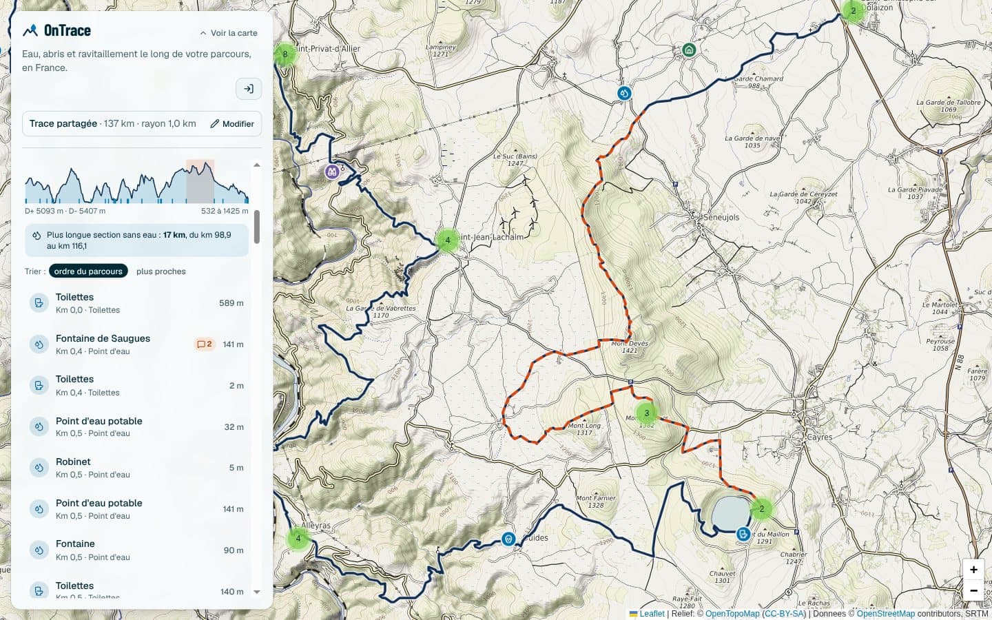
Screenshot of the OnTrace app: a 137 kilometer track on the map, its longest stretch without water in orange, the list of places on the left and the elevation profile below the map.

What it brings you.

  • Shorter preparation

    The route, water, shelters and supplies are on the same map, with their kilometer. You stop looking for them one by one.

  • A safer route

    Long stretches without water, defibrillators, pharmacies and tricky passages are spotted before race day, not during it.

  • A team that coordinates

    Everyone notes what they know on the place it concerns, with a clear role: read, comment, manage. No more lost messages.

  • Knowledge that stays

    What your teams saw in the field stays attached to the trace, and is there again from one edition or season to the next.

Zones and transport, on the trace.

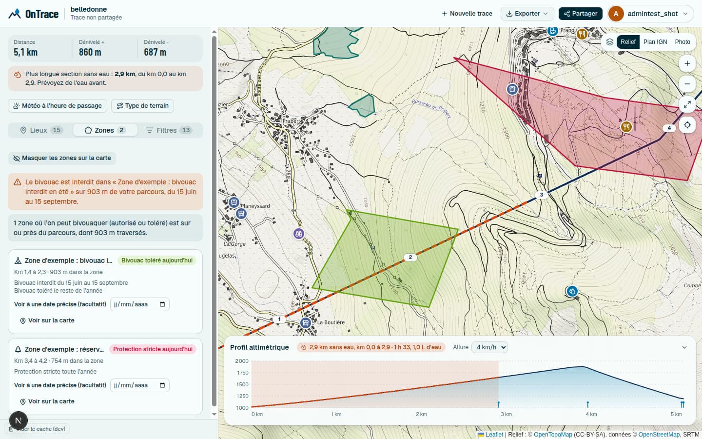
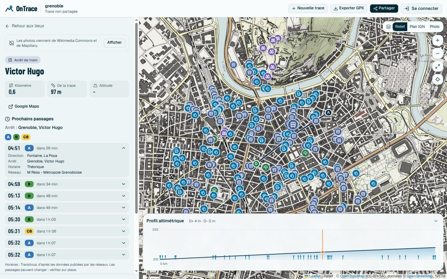
Where camping is allowed, tolerated, restricted or forbidden, in which parks and nature reserves, and when. Bus, tram and metro stops with their next departures, regional coaches included. All of it is in the app today.

Screenshot of the app: a trace with two zones drawn on the map and the Zones tab warning of a camping ban, with its periods.
Screenshot of the app: the card of a tram stop with its lines in color, its next departures and the details of one departure.

Four ways to prepare better.

For each trade, what OnTrace does today, and what the Pro offer adds. Each line says whether the feature is available or being built with you: the demo shows you the real state.

Alpine club, sports or leisure association, non-profit? The Asso offer is free and made for you.

Race and event organizers

The course changes until the last week, volunteers are spread out, and water, aid and first aid points live in three different files.

Today

  • The no-camping zones and protected areas the course crosses, with their periods, and the bus, tram and train stops for volunteers.
  • The longest stretch without water and the profile, to put aid stations where they matter.
  • Defibrillators, pharmacies and tricky passages spotted along the course, with their kilometer.
  • Each volunteer comments on the places in their sector: dry fountain, narrow access, room for a station.
  • The state of each place as reported by the public, dated, with a confidence level: a dry water point leaves the calculation.

With the Pro offer

  • Available: carry your aid stations and zones over from one distance of your race to another, without placing them again.
  • Available: a station plan (aid, first aid, marshals) laid on the trace, with printable sheets per team.
  • Available: a safety file in PDF, and a library of approved traces to compare one edition with the next.
  • With you: your points and zones shared with the whole team.

One shared recce, instead of ten conversations and three spreadsheets.

Trekking agencies and tour operators

On a multi-day trek, a stage with no water and no lodging must not be discovered on the day.

Today

  • Where camping is allowed, tolerated or forbidden along the route, and the protected areas your clients must respect.
  • Huts, hikers’ lodges, campsites and accommodation along the route, with their distance from the trace.
  • Long stretches without water flagged before the stages are fixed.
  • A link to send to the client or the guide, so everyone sees the same route.

With the Pro offer

  • Available: a roadbook readable without signal, to hand to every traveller.
  • Available: a map to embed on your website, in your colors, to present your routes.

Checked stages, and fewer surprises to handle during the trip.

Mountain guides and leaders

Before an outing, you note where to fill bottles, where to stop, and which passages need care.

Today

  • Camping rules and protected areas along the trace, with their calendar, and your own zones drawn freehand.
  • Your notes attached to places, visible to your team and read again from one year to the next.
  • The profile and the kilometer of each point, to brief the group on the key moments.
  • A view that works on a phone, out in the field.

With the Pro offer

  • Available: a roadbook readable without signal, to keep on the phone.
  • Available: a space shared by the guides of the same company.

Less repeated preparation, and a group that knows where it is going.

Tourist offices, local authorities and parks

A waymarked route is only worth something if people know where to drink, sleep and eat, and if that information stays right.

Today

  • Camping zones and protected areas on the map, and public transport stops with their next departures.
  • Water, toilets, shops, accommodation and viewpoints spotted along the trace.
  • Open data (OpenStreetMap, refuges.info), so you never start from a blank page.
  • Comments from the people you invite, to report what has changed.

With the Pro offer

  • Available: a database of places that belongs to you, imported from a CSV or a GPX, for your water points and visitor areas.
  • Available: an embeddable map and an API with webhooks to feed your website.

A route that is more useful to visitors, and simpler for you to maintain.

Free or Pro: what changes.

Everything needed to prepare and share a route stays free for everyone. Pro adds what an organization needs to work together, publish and be supported.

What OnTrace free and OnTrace Pro include, feature by feature
FeatureFreeFor everyoneProOrganizers and professionals
Prepare the route
Places along the trace, with their kilometerWater, huts, food, emergency services, viewpointsIncludedIncluded
Longest stretch without water and interactive profileIncludedIncluded
Reliability of each place and opening hoursDated reports from the public, confidence level, open or closed right nowIncludedIncluded
Camping zones and protected areas, with their calendarCamping allowed, tolerated, restricted or forbidden, protected area or not, period by periodIncludedIncluded
The zones the trace crosses, with the kilometer and the lengthIncludedIncluded
Stops, stations and next departures of buses, trams and metrosIncludedIncluded
Your own zones, drawn freehand, for everyone or just for your traceIncludedIncluded
Your points and zones for the whole team, on a shared traceNot includedIncluded
Carry your points and zones over from one trace to anotherSeveral distances of the same race, without placing your aid stations againIncludedIncluded
GPX export of the chosen placesIncludedIncluded
PDF file of the trace, its sensitive spots and its emergency servicesFor permits and insurance, to print or save as PDFNot includedIncluded
Work as a team
Sharing by link, readable without an accountIncludedIncluded
Roles and private comments on each placeOwner, administrator, commenter, read onlyIncludedIncluded
A space for your organization: members, traces, dashboard, logNot includedIncluded
Several teams, extended roles and sign-in through your company directoryNot includedWith you
Library of approved traces and version historyCompare one edition with the next, know who approved whatNot includedIncluded
Race plan: stations and printable sheets per teamAid, first aid and marshals placed on the trace, with times and contactsNot includedIncluded
Publish and integrate
Map and profile to embed on your website, under your brandA snippet to paste: base map, color, profile, no account needed for your visitorsNot includedIncluded
Your own places: a database of your own, imported in bulkYour water points, access points and visitor areas, from a CSV or a GPX, on your tracesNot includedIncluded
API and webhooks to connect your toolsKeys, daily quota, read access to your traces and places, an alert on each approvalNot includedIncluded
Roadbook readable without signalA file to keep on the phone: kilometers, water, altitudes, opening hours, zonesNot includedIncluded
You and us
Demo on your own traceNot includedIncluded
A direct contact and onboarding on your real tracesOnline helpIncluded
A say in what comes nextThe first Pro features are the ones the first partners ask forNot includedIncluded
A written agreement on your data and its confidentialityTerms of useIncluded
Your files remain yours, your data is never soldIncludedIncluded

Available todayWith youBeing built with the first partners: you shape what goes into it

Let’s build what comes next with the people who use it.

  • You steer what comes next

    The first Pro features are the ones the first partners ask for. Your need comes before one more idea on a list.

  • You keep OnTrace free for everyone else

    Your subscription pays for the hosting, data and development that let individuals search, share and comment without paying.

  • You talk to the people who build it

    A direct contact rather than a support form, and a team that cares about your event going well.

OnTrace is an independent project, built with care. Pro revenue pays for hosting, data and growing the team that builds it.

How it goes.

  1. You write to us

    Two minutes to tell us what you are preparing. Having a trace in mind is enough.

  2. We look at your trace together

    A demo of about thirty minutes, on your own route, with what exists and what is coming.

  3. You decide

    The demo commits you to nothing. If it helps you, we set up onboarding on your real traces.

Your questions.

Where do the camping zones come from?

They are drawn on the map by signed-in people, with a calendar, and reviewed by the OnTrace team, who remove what is wrong. Where nothing is drawn, nobody knows: always check locally. You can also draw your own zones, for everyone or just for your trace.

Will the free version go away?

No. Searching, filtering, sharing a trace and commenting on it stay free for individuals and small groups. The Pro offer is precisely what pays for that.

How much does it cost?

We have not set a price list yet. The price depends on your use: number of events, of teams, integration needs. We talk about it during the demo, which commits you to nothing.

What do we actually see in the demo?

What works today, on your own trace if you have one, then what is being built and that you can shape. We tell you clearly what exists and what does not yet.

Where do the places shown come from?

From OpenStreetMap and refuges.info, two open sources. They are not exhaustive: that is why your teams’ comments from the field matter, and why the private database of places is part of the offer.

Are our races abroad covered?

Not yet: for now OnTrace works in mainland France and Corsica. A race that crosses the border, like a tour of Mont Blanc, is accepted as long as it runs mostly in France.

Who stays in control of our traces?

You do. Your original GPX files remain yours, only the people you invite can comment, and we do not sell your data.

What about the protection of our teams’ data?

OnTrace has no ads, and only counts page visits with no cookie and no tracking. Every member of your team can download their data or delete their account in one click, moderation decisions are explained and can be appealed, and a written agreement on your data is part of the Pro offer. The details are in the privacy policy.

How long does it take to get started?

About thirty minutes for the demo. Then onboarding happens on your real traces, at your own pace.

Let’s look at your next trace together.

Tell us what you are preparing. We will get back to you to set up a demo, on your own route if you have one.

  • About thirty minutes, by video call
  • What exists today, and what is being built
  • No commitment on your side

An event, a route, a team: tell us what you want to prepare.